| This function requires Global Mapper Advanced |
The Script Builder will record actions taken in the Global Mapper interface as Global Mapper Script commands. While recording any actions taken that have a Global Mapper Script command will be recorded and listed in the Script Builder dialog. Recorded commands can then be edited and multiple commands can be exported to a single Global Mapper Script file (*.gms).
Note on coordinate transformations: If Auto-Pick is disabled in Geodetic Settings, the Script Builder will record the user’s selected datum transformations when loading layers.
The Script Builder can be found in the Scripting Toolbar and the File Menu.
The Script Builder opens as a floating-pane window that can be re-sized, moved, and docked within the main Global Mapper window.
Right-click on any selected script command in the Script Builder to access the following options:
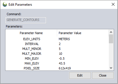
Edit parameters will open a dialog listing all the command parameters and values. Select a parameter and click Edit to edit the parameter value.
Copy command(s) to clipboard will copy the full recorded command.
Remove selected script command(s) will remove the selected command from the Script Builder.
Clear all recorded script commands will erase all the recorded commands from the list.
 Record
Enabled when the tool is first open the record button begins recording the actions taken in the Global Mapper interface to Global Mapper Script commands.
 Stop
Stop
Click to stop recording. A stopped recording can be resumed by clicking the Record button.
 Export
Click to export the checked off items in the list of script commands to a single Global Mapper Script file (*.gms). You will then be prompted to save the file to a location on your machine.
 Editor
Click editor to open the checked off items in the list of script commands as a single script in the Global Mapper Script Editor. The Script commands can then be edited and added to manually and saved to a file from the Script Editor.
Some Supported Script Commands
General
Import
IMPORT_DIGITALGLOBE
IMPORT_IMAGEBUILDER
IMPORT_INTERMAP
IMPORT_ONLINE
IMPORT_TERRASERVER